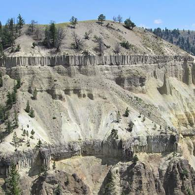
Just a quick posting of a wonderful rock formation in Yellowstone National Park. Note the two layers of columnar lava rock. Recall the Devil’s Causeway in Northern Ireland or Devil’s Tower a couple of hundred miles to the east of Yellowstone in Wyoming. That Devil was a hard working demon.
Slow solidification and shrinkage of the cooling lava flows from earlier vulcanism led to this columnar structure. There is a pull-off across the road next to what must be the upper layer where the photo was taken. I skipped across the road to get a closer look. After 5 minutes I noticed the sign warning not to go next to the formation due to the danger of falling rock. At least there wasn’t a bison standing there as well.
In researching a newspaper article on the expansive clay bentonite, I’m reminded of the rich geochemistry and mineralogy of silicates and aluminates. A visit to the Wikipedia page for silicates reveals a taste of the variety of silicate structures. The clays under discussion here are of the sheet silicates also characterized as phyllosilicates. When the word ‘bentonite’ is used, it is understood to mean a clay with at least 70 % montmorillonite.
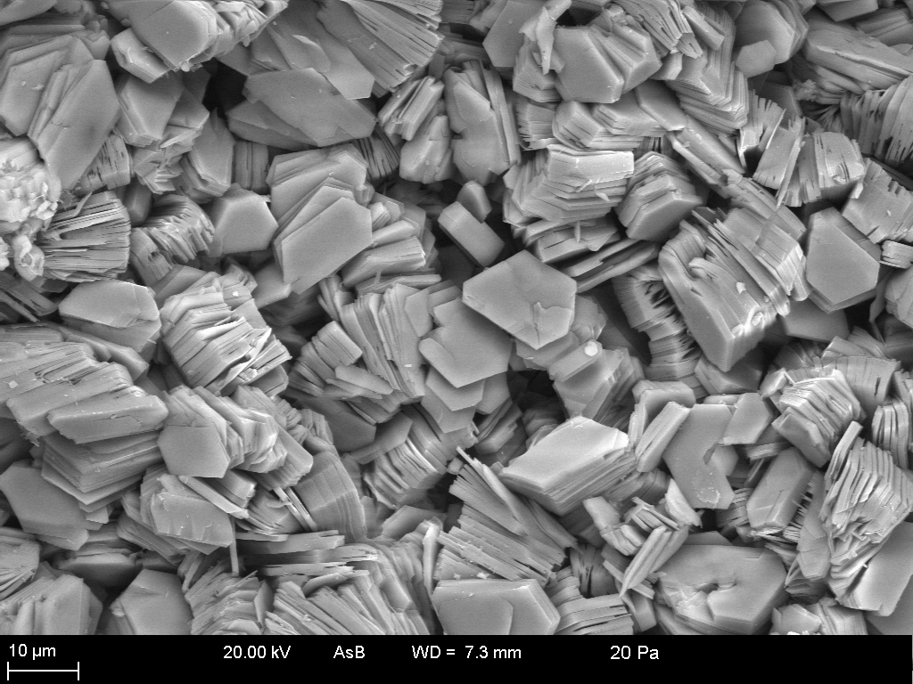
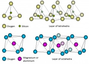
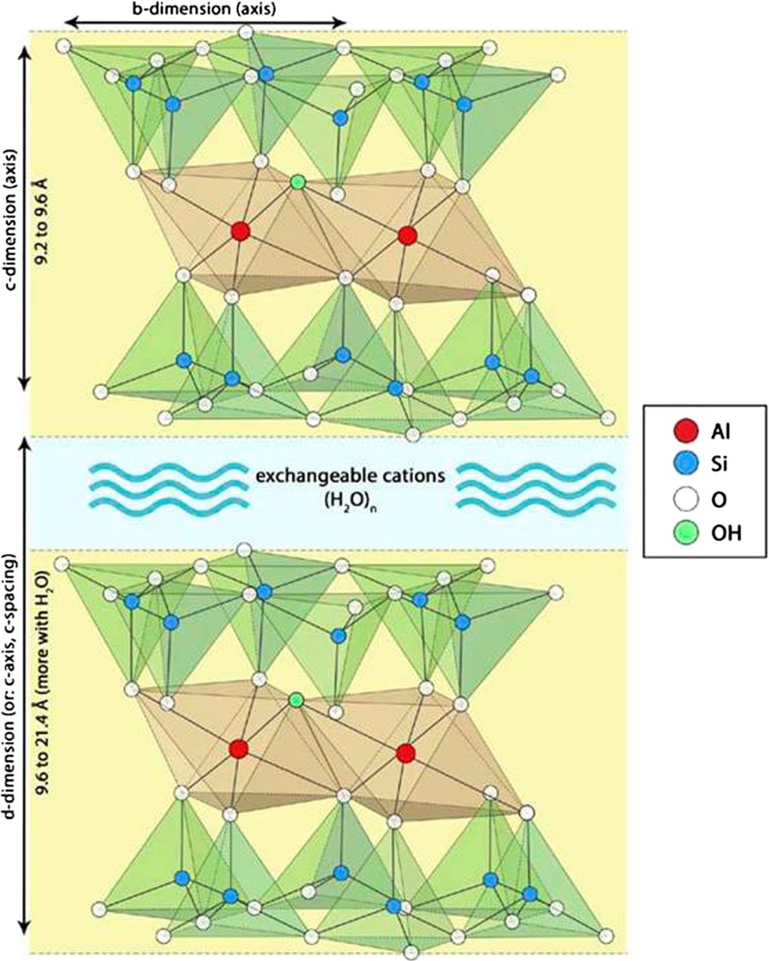
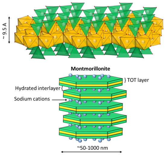
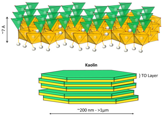
The two clays mentioned here are layered structures comprised of silicate tetrahedra (T) and aluminate octahedra (O). Kaolinite would then be classed as a TO bi-layered structure and montmorillonite is classed as a TOT tri-layered structure. The figure above shows the platy, stacked nature of the phyllosilicates.
Image: Link. Excellent graphics from the European Geosciences Union.
Silicate minerals with a single, isolated SiO44- groups are called orthosilicates. These SiO44- units can be joined at the vertices to form single and double chains, rings, sheets and 3-D networks as in quartz. In the case of chains, etc., the silicon atoms are bridged with oxygen atoms.
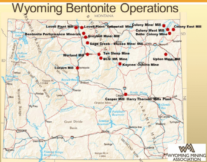
Presently I am writing a piece about the sciency aspects of bentonite, a clay responsible for expansive soil. A local McBurger restaurant has closed temporarily due to structural problems caused by expansive soil which is symptomatic in the region. For geographical context we are in north central Colorado between Cheyenne, Wyoming, and Denver, Colorado. The presence of troublesome bentonite-containing expansive soils in the area is well known. In fact, there are many bentonite mines in Wyoming, one with milling operations in Casper, WY.
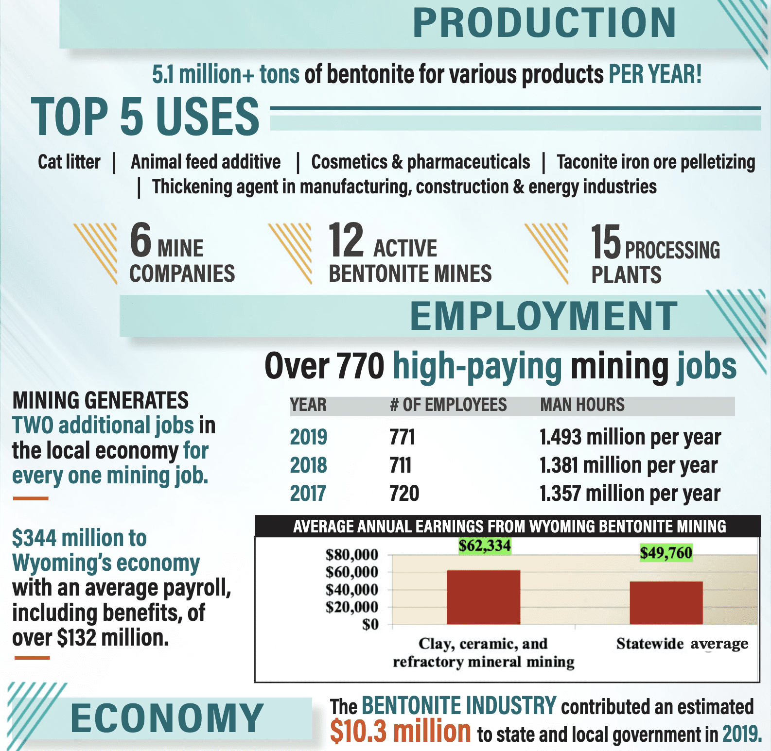
According to the Wyoming Mining Association, Wyoming has 70 % of the world’s and 93 % of the USA’s known bentonite deposits.
Bentonite can be harmful to roads and building foundations but also serves as an important raw material. It is used primarily in drilling muds, cat litter, cosmetics, pharmaceuticals, animal feeds and other applications.
Image: Link. Creative Commons.. DO – 10.1186/1476-511X-13-153
ImaLink. Nieto, S.; Toro, N.; Robles, P.; Gálvez, E.; Gallegos, S.; Jeldres, R.I. Flocculation of Clay-Based Tailings: Differences of Kaolin and Sodium Montmorillonite in Salt Medium. Materials2022, 15, 1156. https://doi.org/10.3390/ma15031156ge:
The class of expansive clays relevant here are the smectites. Bentonite is a smectite and has mineral composition rich in the montmorillonite member of the smectite group. In short, montmorillonite can attract waters of hydration to a great extent depending on the cation sub-type of the montmorillonite. The sub-types include Na+, K+, Ca++, Mg++, Fe++ counter-ions. A common cation in montmorillonite is sodium cation. The high water solubility of sodium salts in general allows for it’s replacement by other cations.
The montmorillonite unit structure consists of 3 layers similar to the stacking of an Oreo cookie. The inside cream layer consists of a sheet of aluminate octahedra. The two sandwiching cookie layers are sheets of silicate tetrahedra. The net effect is that the internal surplus negative charge carries through to the exterior surface of the sandwich. This charge attracts water layers and cations that will coordinate to the cookie surface to balance the charge. This attraction to cations and water leads to expansion of the unit structure the mineral and therefore swelling of the bulk material.
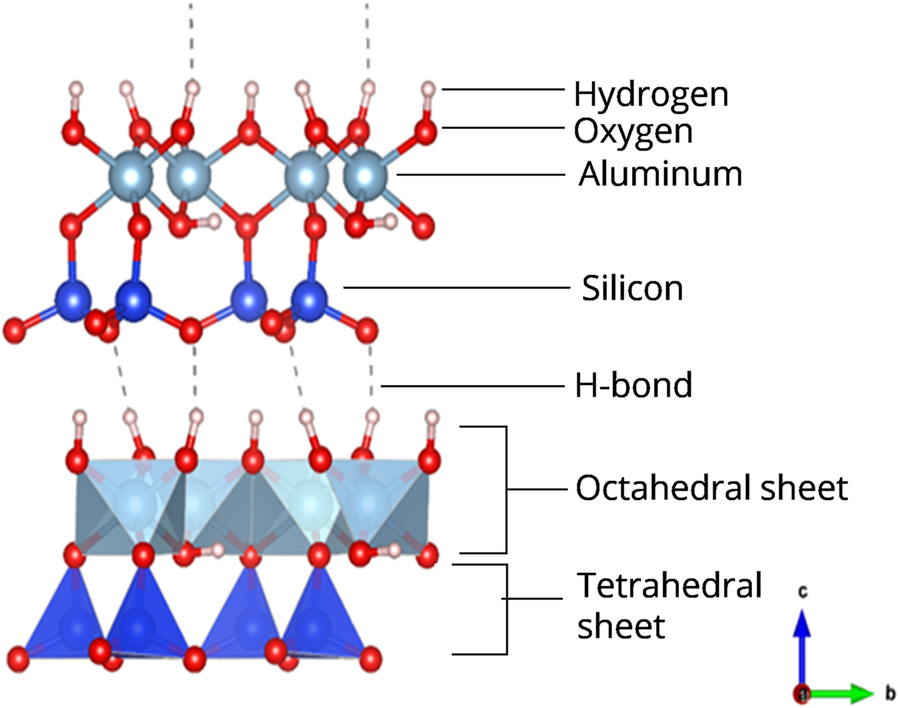
Kaolinite is comprised of bi-layers of a tetrahedral silicate sheet intimately bound to an aluminate sheet with no intervening layer of hydrates. The direct stacking of the kaolinite plates absent the water layer physically prevents water from migrating between plates and leading to swelling. Kaolinite is not an expansive clay.
Image: Cambridge Core (Paywall) , a ball and stick drawing of a Kaolinite silicate layer on top of a octahedral aluminate layer.
The pottery clay familiar to most of us is comprised mostly of kaolinite. While not a smectite, kaolinite (above) has just a single tetrahedral silicate layer connected to an octahedral aluminate layer to make a flat platy structure.
Image: Link. Nieto, S.; Toro, N.; Robles, P.; Gálvez, E.; Gallegos, S.; Jeldres, R.I. Flocculation of Clay-Based Tailings: Differences of Kaolin and Sodium Montmorillonite in Salt Medium. Materials2022, 15, 1156. https://doi.org/10.3390/ma15031156
Both mechanochemistry and abiogenesis are each pretty deep subjects, and this essay will not due either of them justice. This is just a nudge to the curious out there.
I follow a Facebook page called “Abiogenesis”. It usually posts links to the primary literature and recently to a very intriguing paper. It is titled Mineral-mediated carbohydrate synthesis by mechanical forces in a primordial geochemical setting, The link is –https://doi.org/10.1038/s42004-020-00387-w. and is published by Nature.
Should the unthinkable arise and you, the gentle reader, are unfamiliar with mechanochemistry, I would suggest a free ACS pdf download (Free! Will yah look at that!) with some basics. Ms Google can offer many more links. This was new to me but not to the light of day.
Sorting out abiogenesis is difficult enough in the solution phase, but these workers have included geological surfaces into the mix. And directed to carbohydrates no less. It is ambitious but the field needs ambitious experimental work.
My guess is that most chemists coming through the undergraduate ACS core curriculum are as unfamiliar with mechanochemistry as am I. A chemistry or geochemistry faculty member involved in it would be needed to teach an elective for it. I’ll hazard a guess that mechanochemists are somewhat scarce on most chemistry faculty rosters at present. Geology departments offer geochemistry courses, but it is unlikely to overlap with the chemistry department. How often do chemistry faculty mix (or party) with the geology department? I know that before I began to study it, I dismissed geochem as boring dirty water chemistry. But, as I am finding out, the dirty water is quite interesting.
Oh to be a geologist, merrily tramping around in the weeds and the sunshine, swinging a rock hammer and collecting pretty rocks with a legitimate purpose.
Mechanochemistry definitely expands one’s horizons in chemistry. But what is mechanochemistry? The Wikipedia link above does a fair description of it. The thing is, rocks are frozen mixtures of minerals, usually with very low water permeability over short time spans and at sometimes at temperatures we ordinary chemists are unaccustomed to working with.
An analogy
I trained new employees in electrostatic discharge (ESD) safety at our chemical plant. We look at the friction of two surfaces in physical contact sliding past one another. It is easiest to think about dissimilar substances in this picture. As contacting surfaces slide, the surface electrons have the opportunity to stay put or jump to the other, more attractive surface. Electrons migrating away from a nonconducting or electrically isolated conductor surface leave positive charge behind. This is called the triboelectric effect. Furthermore, such mechanical friction generates heat as we all know, especially when one or both surfaces have irregular surface topography such as bumps, crystalline or amorphous protuberances and ridges at the submicroscopic scale. Friction is magnified when external forces concentrate at regions of pronounced submicroscopic topographies, meaning where the lumpy, edgy or mountainous features move past one another.
Have you ever generated a spark when two objects make a glancing blow? A good example would be using a flint and steel to light a campfire. The sparks come from small flakes of metal catching fire in the air. The small flying pieces are very hot but are exhausted rapidly. Cigarette lighters have been doing this for decades by rolling a fixed roughened wheel across a flint. The sparks generated are white hot as judged by their momentary brightness.
Well, that’s nice but what is the connection to mechanochemistry? Generating incandescent bits of metal is an example of how a great deal of energy can be applied to a very small solid surface feature. Now let’s back off the energy a bit and consider the rocks in a rock polisher. A rock polisher works by prolonged tumbling of rocks with small bits of very hard material like carborundum or cerium oxide abrasives. As the rocks tumble, they collide with one another. If during the collision there are abrasive particles at the point of contact, a small amount of chipping of both rocks might occur. The surface chipping will plateau at a particular surface smoothness depending on the size of the abrasive particle. Smaller and smaller abrasive particles will produce finer roughness until such point as humans might regard the rock as “smooth or polished.”
We’ve seen that fracturing of a rock surface can occur with an input of mechanical energy over an extended period of time. Highly localized individual surface features might be subject to mechanical energy input that is high in magnitude. In polishing, mechanical energy has disrupted the molecular structure of the surface matrix of the mineral. Fresh surfaces of rock are free to adsorb water or metal ions may swap anions if the atomic radii are similar and the ionic charge is the same. In swapping metals of like charge or just opening a molecular or atomic coordination site, a chemical transformation has happened. The chemical identity of a mineral structure at newly opened surfaces are different from those that have been weathered. This is because water can coordinate and alter the surface composition as a hydrate to begin with. The interior may be anhydrous, but the new surface becomes hydrated. Anhydrous substances are slightly different from their hydrated form. Hydration has several levels- coordinated water bou8nd to a metal ion, water of crystallization within the crystal lattice but not coordinated, or discrete water between crystals. The word “hydration” itself is not very specific, but the context may be written to infer more precise meaning.
Some organic chemicals like explosives are shock sensitive. A good example is nitroglycerine. Shock sensitivity is the application of mechanical energy to the substance, in the case of nitroglycerine, undergoing a chemical transformation begins with the breaking of the weakest covalent bond. This leads to a rapid cascade of transformations and the evolution of hot gases. Oh, and a shock wave too. Notably, these rapidly evolving hot gases occupy more space that did the liquid nitroglycerine, famously doing pressure-volume work on the surroundings.
This long, drawn out explanation leads to a point- Chemical change can and does occur at mineral surfaces. The application of mechanical forces to a solid can result in contact surfaces receiving a large input of mechanical energy. There are mechanical and chemical consequences as well as triboelectrical effects. In the case of a flint and steel, combustion can occur if just momentarily.
Back to Abiogenesis-
Minerals can be altered chemically somewhat through impact and sliding friction. The mineral itself can be altered but more to the point, if prebiotic substances are present near the contact they might be subject to the energy input which can manifest as localized and momentary heating.
Let’s not forget the mineral surfaces themselves. A given mineral may be an ionic substance where the ions are locked into a lattice. Furthermore, the distinct crystallographic surfaces may be chemically reactive in their interactions with the environment.
This is as far as I’m willing to go down this dendritic Google hole. More to follow. Have a good day!
I’m happy to speak highly of a retired petroleum geologist who produces excellent geology video content for YouTube. His name is Myron Cook, and he lives in Wyoming; he loves the geology of Earth. He is a very prolific videographer and is known as the “Bob Ross” of geology for the genteel narration of his field trips in Colorado, Wyoming, and Utah. His manner of speaking and folksy explanations are suitable for the general public, but he manages to avoid patronizing oversimplification of geology. What is nice is that all of the formations he explains can be visited.
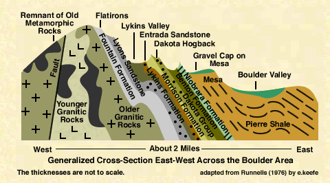
Source: Cross sectional sketch of the stratographic geology the basement rock protruding upward through the layers of sediment pushed upwards by the Laramide Orogeny. This represents the formations adjacent to Boulder, CO. Excerpted from “Boulder, A Sight to Behold: Guidebook” (1976) by Donald D. Runnells, modified by Sheila Murphy
His videos are well-produced 20-40 minute intro-level geology seminars, combining his aerial photography, whiteboard talks, and field trip adventures into geologically interesting terrains on the Colorado Plateau and up into Yellowstone and the Bighorn Mountains in Wyoming. He is particularly adept at explaining sedimentology, an area in which I previously held little interest, but for no good reason. That has since changed.
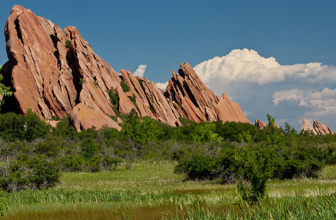
If you live along the Colorado Front Range like I do, you’ll recognize the Boulder Flatirons, Red Rocks Amphitheater, and the Garden of the Gods in Colorado Springs. These steeply dipping conglomerate formations sit at the juncture of the Great Plains and the eastern foothills of the Rocky Mountains. They are part of the Fountain Formation, which extends steeply downward and toward the east. The formation is named for the Fountain River, where the layer was identified.
Source: Wikipedia. Fountain Formation exposure at Roxborough State Park near Denver.
Myron Cook has an excellent YouTube introduction to the Fountain Formation of Colorado. The rocks of the Fountain Formation are thought to be 290 to 340 million years old.
Mr. Cook began a video by asking the question “Is the Fountain Formation composed of sediment from the Rocky Mountains?” Well, sort of, but first consider how the adjacent sediment layers are situated. Next to the Front Range, numerous layers of sedimentary rocks lie pancaked together and aligned substantially vertical. The rule of thumb in sedimentary geology is that the oldest sediments are at the bottom and they accumulate going upwards. There are scattered apparent exceptions, but they are few and do not negate the rule.
The Fountain Formation is an alluvial fan formation of coarse red feldspar-rich granitic arkose. All of the exposed sandstone and conglomerate layers lying a few miles eastward from the Fountain Formation are likewise tilted upwards. These sedimentary exposures are not limited to the Front Range but also appear on the western slope of Colorado.
Vocabulary Update
How is ‘alluvial’ different from ‘fluvial’?
Fluvial (The Process): Relates to the erosion, transport, and deposition by active river channels. Examples include river channels, canyons, and waterfalls.
Alluvial (The Deposit): Refers to the material laid down by water, often outside the main channel during floods. Examples include alluvial fans, floodplains, and sandbars.
Usage: “Fluvial” describes the system or environment, whereas “alluvial” describes the sediment type or landform.
Source: Google (search terms: ‘alluvial versus fluvial’)
There is nothing strange about arkosic alluvial fans, except that in this case, it dips so steeply that much of it sits directly in contact with the granitic/metamorphic basement rock which is at a depth of about 10,000-11,000 ft of sediment below eastern Denver. If the alluvial fans were recent, they wouldn’t rest on the basement rock. Instead, they sit roughly two miles below many sedimentary layers. In general, the lower the sediment layer, the older the formation. Exceptions exist, and for very interesting reasons. The Fountain Formation is very old.
Another plug
If you have not visited Utah, you’re really missing out on a vast landscape of stunningly beautiful red sandstone formations. Even if geology does not do it for you, the sheer beauty of the many red river canyons, cliffs, arches and oddly eroded features should rouse the coldest of souls. Let your spouse drive so you can take in the view, just don’t say that.
Back to it
The present Rocky Mountains are thought to have begun in a third mountain building episode roughly 55 to 80 million years ago (MYA) called the Laramide Orogeny. These earlier mountain ranges are called the ‘Ancestral’ Rocky Mountains. This orogeny was the result of tectonic activity lifting mountains in New Mexico, Colorado. into Wyoming and Utah. Going north along the Rockies are other named orogenies.
The occurrence of mountain building of the Rocky Mountains far from a coastal subduction zone is rather odd. One of the more popular explanations is that subduction of the Farallon plate is unusually shallow, creating compression and uplifting far inland from the coastal subduction zone. When you push a rug or tablecloth, you’ll note that the rug or cloth will cause ripples in the direction of motion. This is similar to mountain building. It could also cause repetitive mountain building. This NASA link describes the subduction of the Farallon plate.
The Fountain Formation is much older than the present Rockies. This formation is believed to have come from the erosion of the Ancestral Rocky Mountains. But which one? One source makes reference to two prior ancestral ranges. The earliest is referred to as the Precambrian mountains and not much is known about it. It predates the Western Interior Seaway.
A second iteration of the Rocky Mountains from the next Laramide orogeny rose ca 300 MYA in the Late Pennsylvanian and Early Permian geologic periods. It was eventually eroded flat and carried away as sediment by wind and water. Sediments, i.e., sand & mud, are layered in ways that are consistent with alluvial fan formation.
Finally, 55 to 80 MYA the current iteration of Rocky Mountains arose from the Laramide Orogeny. In numerous places in or near the Rockies fossilized clams and oysters can be found at the surface. This further supports the past presence of the Interior Western Seaway.
I just remembered that I’m not writing a book. Ciao!!
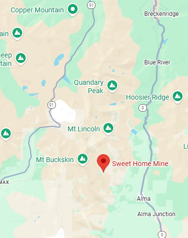
Not a single reader has asked about the photograph in the header of this blog, so I’ll save the many peoples of the world from having to ask. Mineral collecting has been a lifelong weakness of mine so there was no surprise when I bought the pink mineral in a rock shop in Leadville, Colorado. The pinkish mineral in the sample is rhodochrosite, the state mineral of Colorado. Like most samples, it comes from the now-closed Sweet Home Mine, a failed silver mine in Buckskin Gulch outside of Alma, CO, between Breckenridge and Fairplay. If you are ever in Denver with spare time on your hands, the mineral collection at the Denver Museum of Nature & Science has a stunning collection on display of rhodochrosite from the Sweet Home Mine.
Source: Google Maps. Location of Sweet Home Mine outside of Alma, Colorado.
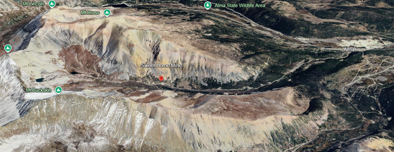
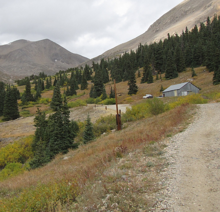
To get to the site take gravel road 8 from Alma up Buckskin Gulch which eventually terminates at a trailhead near the base of several fourteeners in the Mosquito Range. We once tried to find the mine by driving up the gulch above Alma, but there were no signs identifying the mine.
Source: Google earth. Location of Sweet Home Mine in Buckhorn Canyon.
While we did not positively identify the mine on our trip, a photograph (below) was found later of a building associated with the mine. We did see it but sailed right on by. The mine is located on private property so wandering around the site is not permitted.
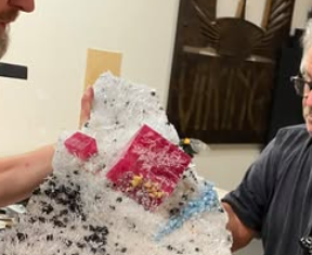
Source: Facebook. The famous Alma King rhodochrosite specimen with museum dudes for scale.
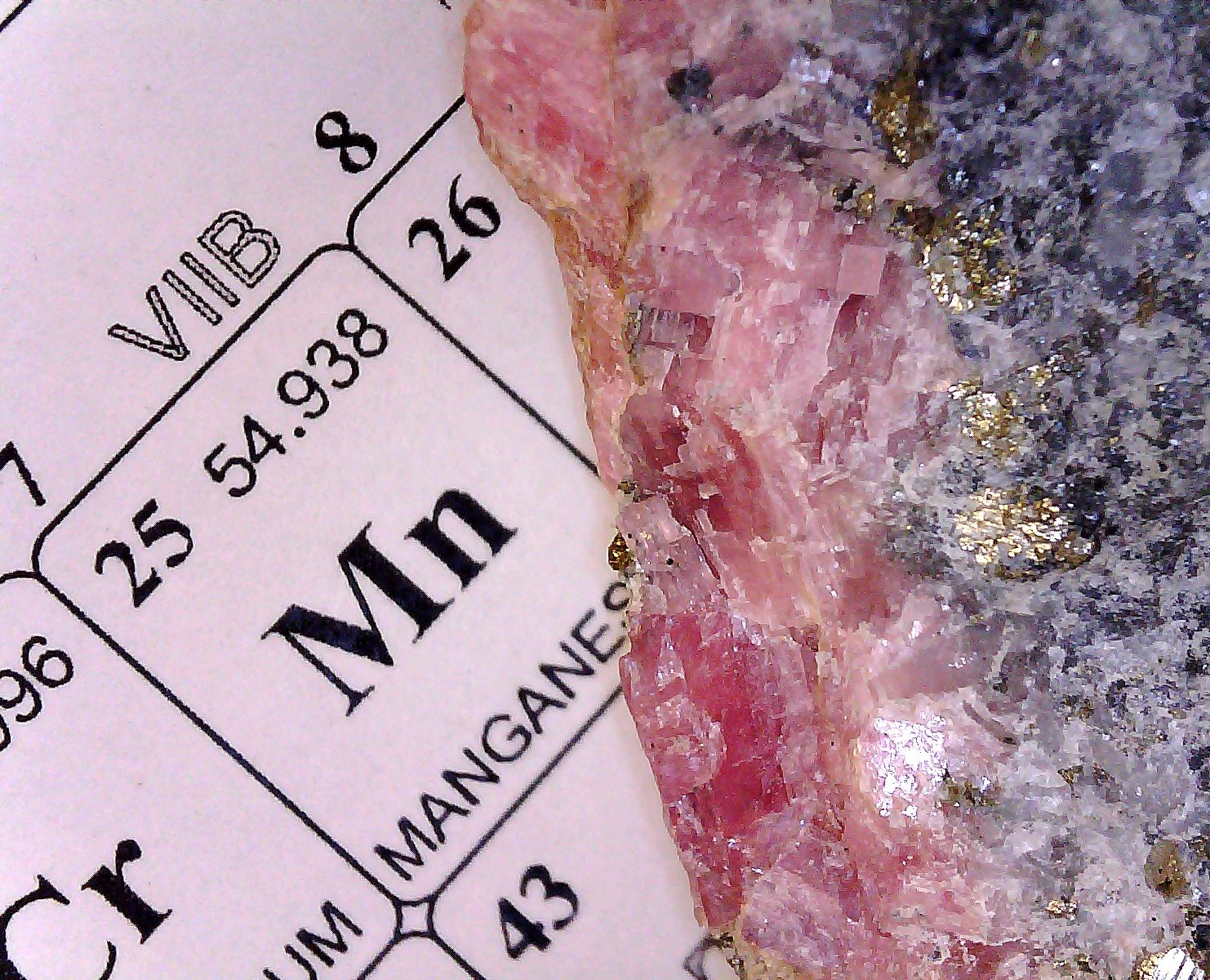
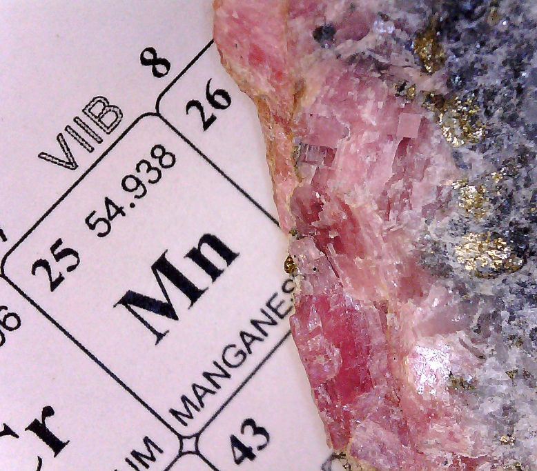
Source: personal specimen purchased at a rock shop in Leadville, CO. The rhodochrosite section is placed next to manganese on the periodic table just because it looked cool. The gold-colored bits on the specimen are likely chalcopyrite.
The mining district was discovered in the usual way- the search for placer metals like gold led miners up Buckskin Creek into the gulch looking for the source of the lode deposit. Originally a silver mining claim was made in 1873. The sporadic silver mining operation was abandoned in 1966. In 1991 the mine was bought out by Collector’s Edge Minerals, a consortium, and modernized. After a period of activity, the Sweet Home Mine was closed in 2004. However, another mine called the Detroit City Portal was begun by Collectors Edge on nearby Mt. Bross in 2016. This new operation, yielding many fine specimens was finally closed in September of 2024.
Source: Mindat.org. Looking north towards the Sweet Home Mine and what appears to be Mt Democrat on horizon.
“Mineralization is generally in base metal-silver-rhodochrosite-fluorite veins predominately hosted by meta-igneous and metamorphic rocks, with minor mineralization in porphyritic dikes and pegmatites. There are five main veins in descending order of production: the Main, Tetrahedrite, Watercourse, Blaine and Blue Mud veins. The Blue Mud Vein is a barren post-mineralization fault-vein, and production from the Blaine Vein was minor. Overall, the planned extent of the mine is small (1000 feet x 400 feet) with about 5,000 feet of workings, and the overall hydrothermal alteration zone small, despite evidence of on-strike continuation of the veins in the collapsed Tanner Boy workings directly across Buckskin Gulch. And even within a vein, rhodochrosite finds were limited.”
“Three conditions were responsible for the formation of vugs: (1) changes in strike and dip of veins, (2) vein intersections, and (3) openings formed by fault bends controlled by host rock foliation. In general, the 2nd condition was responsible for major pockets, and the 3rd for most smaller pockets. Exploration focused on fault/vein intersections. Fluid inclusion studies suggest that the hottest fluid flow produced the gemmiest ruby-red rhodochrosites.” Minedat.org
Deposits found in the mine result from mineral-saturated hydrothermal fluids moving from the mineral source-rock into faults and fractures in the formation that were cooler, leading to precipitation of the minerals. The large size of the rhodochrosite crystals in the museum collection suggests that the precipitation was gradual.
According to Minedat.org, after the buyout of the Sweet Home Mine by Collector’s Edge Minerals and subsequent modernization, ground penetrating radar was used to survey for vugs. According to the AI overview by Google in a search for “vugs”-
Vugs are- “small to medium-sized hollow spaces or cavities within rocks, often lined with beautiful, well-formed crystals like quartz or calcite, formed by mineral-rich fluids filling natural voids left by dissolution, tectonic shifts, or gas bubbles in volcanic rocks, prized by collectors for their exposed crystal formations.”
Only makes sense, right? Liquids within voids in the rock have the opportunity for crystals to grow into. Vugs are associated with faults and fractures which can be filled with hydrothermal fluids within a formation. Lode gold, silver, lead, etc., as well as quartz may line or even fill the vug. This is why some of the best mineral crystals are only found in mines and this certainly applies to rhodochrosite. Rhodochrosite contains manganese (II) which is oxidizable to a higher, more positive oxidation state, so protection from atmospheric oxygen deep within a rock formation prevents decomposition of the mineral.
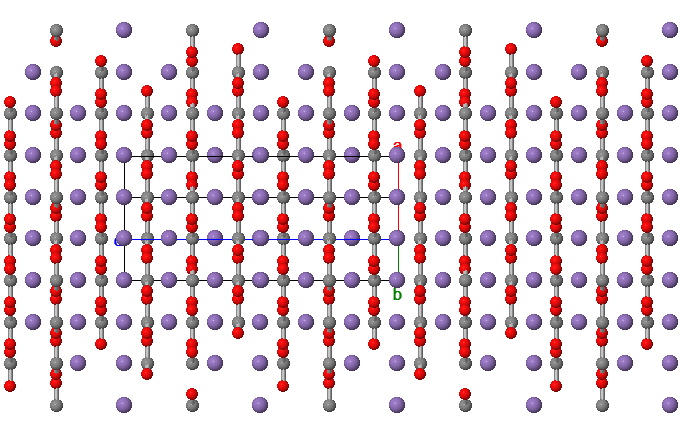
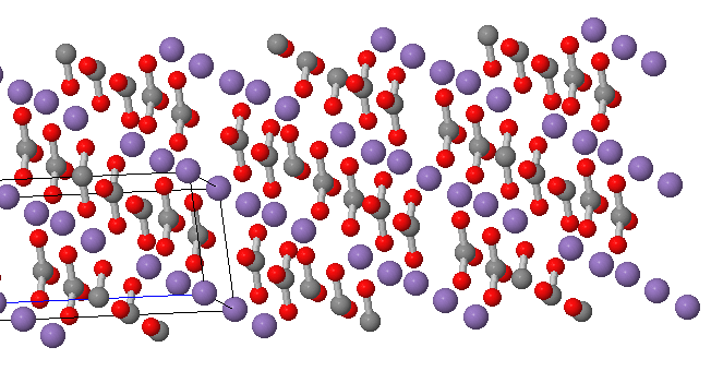
Crystallographic structures of rhodochrosite are shown below-
Source: Mindat.org. A view of the crystal structure rotated to see the planar arrangement of Manganese (2+) in purple and carbonate anions (2-) in grey and red.
Source: Minedat.org. In this view the alternating layers of carbonate anions (CO3 2-) delineating the carbon and oxygen atoms. The trigonal shape of carbonate can be seen.
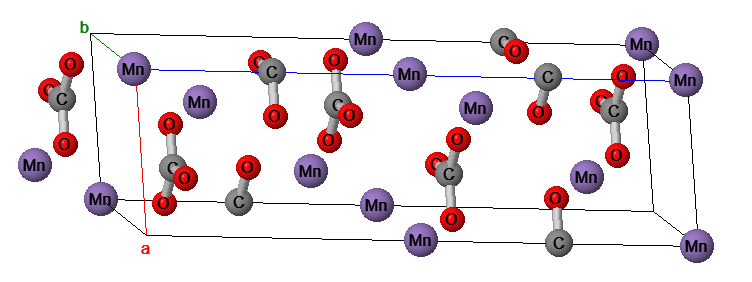
Below is a representation of the unit cell with atom labels. Clear images are tricky with crystal structures. Overlapping features are hard to avoid.
Source: Minesdat.org. The labeled unit cell of rhodochrosite. Partial carbonate structures can be seen contributing to the unit cell.
Rhodochrosite is manganese (II) carbonate, MnCO3, and is insoluble in water but as a metal carbonate it is acid sensitive and therefore subject hydrolysis or chemical or microbial oxidation to Mn(III) or Mn(IV). Like a great many common ionic substances, it is not regarded as suitable for jewelry applications because it is not comprised of silicate or aluminum silicate subunits common in semiprecious and more robust minerals like sapphire, beryl or garnet. The structure is composed of MnO6 octahedra connected by trigonal carbonate units. The large buff-colored balls are manganese atoms and the smaller, bluish-colored balls connected directly to the manganese atoms are oxygen atoms. The middle-sized darker balls not connected directly to the manganese atoms are the carbon atoms of carbonate.
Manganese is not uncommon in the Colorado Rockies. A mining geologist once complained to me that there was so much manganese in their gold mine tailings that it was a regulatory problem for them. For a time pyrolusite, or manganese dioxide (MnO2), was mined in Colorado, near Salida. Never a large operation, pyrolusite could be used in the extraction of gold from its ore.
Crushed pyrolusite was placed below a wooden container along with sodium chloride. To this mixture was added concentrated sulfuric acid. This generated gaseous hydrochloric acid which was then oxidized by the manganese dioxide in the pyrolusite into chlorine gas which flowed up through the container of gold ore combined with the gold ore and generated gold chloride. The water-soluble gold chloride was removed with water, then isolated and into this pregnant solution was dumped scrap iron. The iron reduced the gold chloride and finely divided gold precipitated out. This was a pretty danged clever method for use in the field as it required only water, NaCl, H2SO4 and pyrolusite mineral which could have been mined in Colorado.
Oh, BTW. You might know that a way to generate a stream of fairly dry HCl gas (in a lab fume hood!!!) is to place granular NaCl into a vented flask and slowly drip conc H2SO4 from an addition funnel on it. A stream of nitrogen is used to force a flow of HCl out of the flask and through a sparge tube into your reaction flask.
And, speaking of metals ...
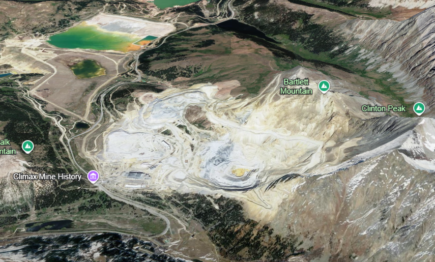
Nearby the Sweet Home Mine, a hop, skip and a jump across the ridge to the NW is the Climax Molybdenum Mine on Fremont Pass just west up the road from the Copper Mountain Ski Resort. This major mining operation is owned and operated by Climax Molybdenum Company, a subsidiary of Freeport-McMoRan. If you look at the image for a minute, perhaps you can see that most of Bartlett Mountain is gone. Just imagine laboring in a frigid mine above the 11,000 ft altitude. I’d be dead by noon the first day …
Source: Google Earth. Just a few miles NNW of the Sweet Home Mine is the Climax Molybdenum Mine on Freemont pass.
The mineral of interest at the Climax is molybdenite, or molybdenum sulfide, MoS2. The deposit was discovered in 1879 by prospector Charles Senter who was actually prospecting for gold or silver. By 1895 Senter found a chemist who determined that the mineral contained molybdenum. At that time, however, there was no market for the moly. In a few years steelmakers discovered that molybdenum had application in steel making and, with the onset of WWI. the mine went into full production after it was discovered that the Germans were using it to strengthen steel in their tanks and weapons.
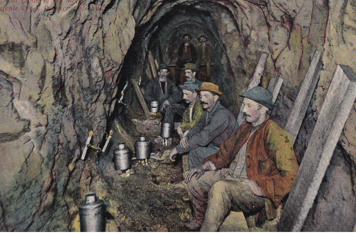
The National Mining Museum and Hall of Fame down the road in Leadville has a large collection of interesting artifacts from early mining efforts at Climax. If you have been in many mines, you’ll know that they are mostly hallways that have been blasted out of solid rock. When mining activity stops, they are eerily quiet.
Image source: National Mining Museum in Leadville, CO. Colorized photo of lunch time in the mine.
Molybdenum sulfide is also valued as a dry lubricant for use in the temperature extremes and vacuum of space. Dry, low vapor pressure lubricants are used to prevent evaporation and contamination of optical surfaces on a satellite.
This is an encore release of a much earlier post. –gaussling
After an insane week in the lab a road trip to the cool meadows of the nearby mountain range was just what the doctor called for. It was the last weekend before the family- one teacher and one kid- return to school. Summer break 2009 is history.
We piled in the car and pointed it uphill towards Leadville, Colorado. The planetary atmosphere thinly blankets this insanely high mountain city. It was just what I needed to clear my scrambled mind. Nothing like blinding sunshine and mild oxygen starvation to reset a brain in chronic spasm from sensory overload.
Leadville sits at 10,152 feet above sea level. If you doubt the effect on your stamina, just take a short sprint in any direction. Or just plod up the stairs of your hotel. Lordy. All of those business dinners- all that lovely Cabernet and Crème Brûlée- and years of driving a desk have caught up with me.
Leadville is located in the Colorado mineral belt and began to populate with fortune seekers about the time of the Colorado gold rush in 1859. Some placer gold was found in the streams, particularly in what was then called California Gulch, but for the most part Leadville became a silver camp.
In 1874, two investors with metallurgical training, Alvinius B. Woods and William H. Stevens arrived in Leadville and analyzed the muds found in the local sluicing operations. According to A Companion to the American West, edited by William Francis Deverell, (2004, Blackwell Publishing, ISBN 0-631-21357-0, p. 319) Woods and Stevens found the heavy black mud so problematic for gold sluicing was in fact composed of lead carbonate with high levels of silver. Woods and Stevens invested $50,000, quietly buying as many claims as they could and began hydraulic mining operations immediately.
By 1890 there were nearly 90 mines in operation employing 6000 miners. At its peak there were 14 smelter operations supporting the mines. Leadville was a genuine boom town with the expected mix of characters.
A mine is a hole in the ground with a liar standing at the top.
All mining towns have characters who go on to dominate local legends and stories. Among the well-known-for-being-famous rags to riches to rags players in Leadville are Horace and Agusta Tabor, along with Horace’s mistress and 2nd wife, Elizabeth “Baby Doe”.
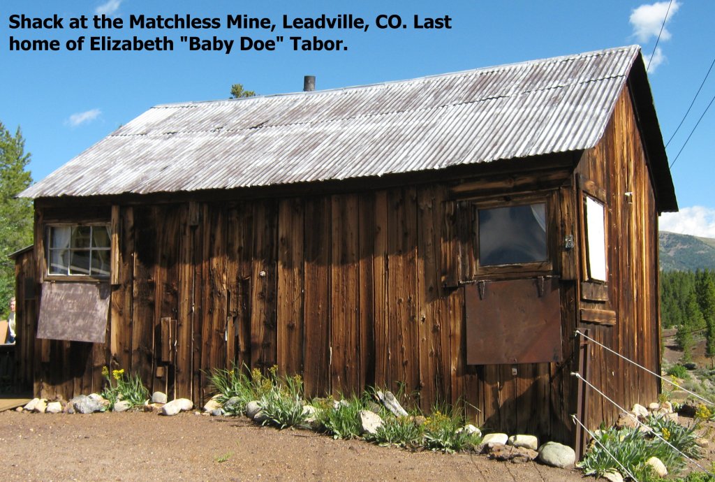
To make a long story short, Horace was a struggling shop keeper who invested in a mine east of Leadville. Though it was salted by the previous owner to entice buyers, Tabor dug 25 ft further down the shaft and struck a rich and extensive vein of silver ore. The operation was called the Matchless Mine, after Tabor’s favorite brand of chewing tobacco.
According to the tour operators, Tabor operated the Matchless Mine 24/7 for 13 years, pulling an average of $2000/day of silver out of it. At its peak, the mine is said to have employed 100 people. Miners were paid the common rate of $3.00 per day to climb 365 ft to the bottom of the shaft for 12 hour shifts.
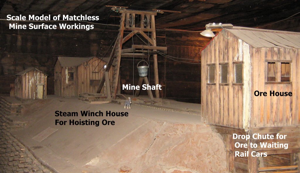
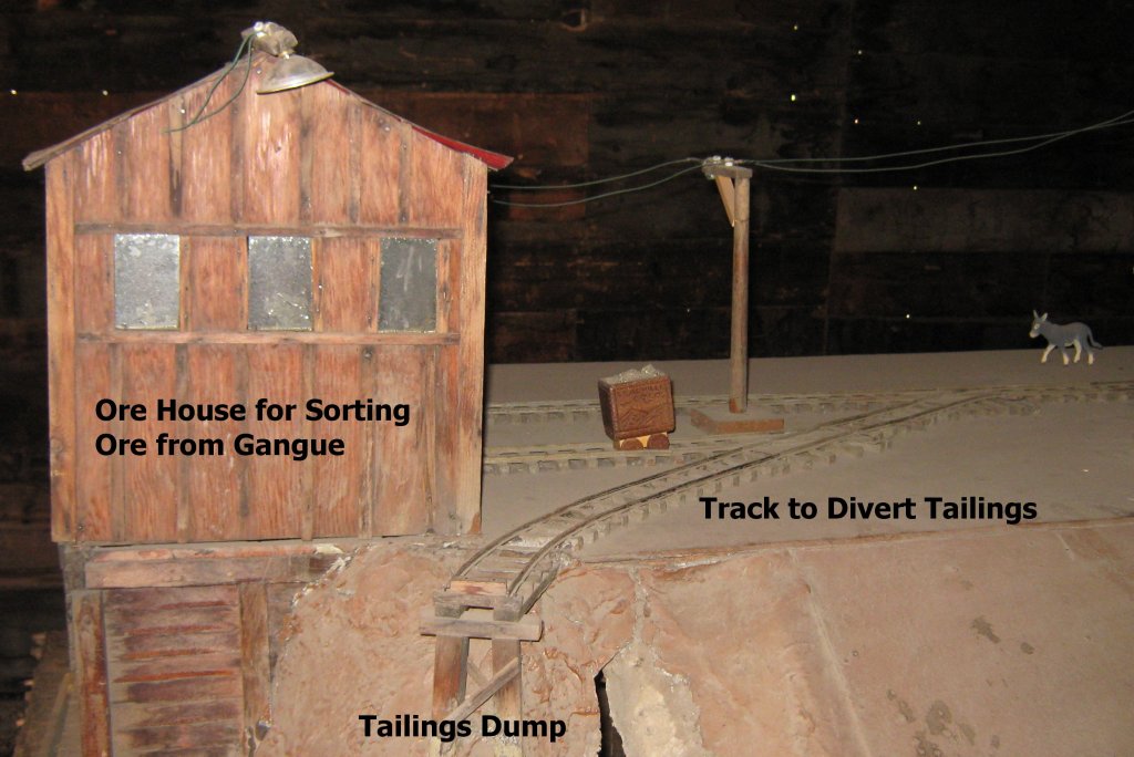
The underground workings of the mine followed the vein structure and focused on sending concentrated ore to the surface. Buckets carrying approximately one ton of ore per load (my estimate) were tipped into ore carts and rolled into the ore house for hand sorting. The most highly concentrated and valuable ore was dumped down a chute for loading into a rail car and the gangue (or tailings) was dumped into the gulch.
An assay building (not shown) was on site to provide a continuous assay and accounting of silver sent to the smelter in Pueblo, Colorado. Unlike many other mine operators, Tabor owned a rail operation and had a spur at the mine for pickup and delivery of ore. Many mine operators had to employ mule-skinners to cart wagon loads of ore to a rail siding for transport to the nearest smelter.
In 1893 the repeal of the Sherman Silver Purchase Act and the collapse of the railroad industry bubble were part of a panic that lead to a crash in silver prices. Tabor lost everything and, as a respected public figure, was appointed postmaster of Denver for a short time. Eventually Tabor died at age 69 in 1899. Ex-wife Agusta had invested her divorce settlement wisely in Denver and lived comfortably. Widow Baby Doe Tabor was found frozen stiff in her shack at the Matchless Mine in 1935.
Matchless Mine Shack
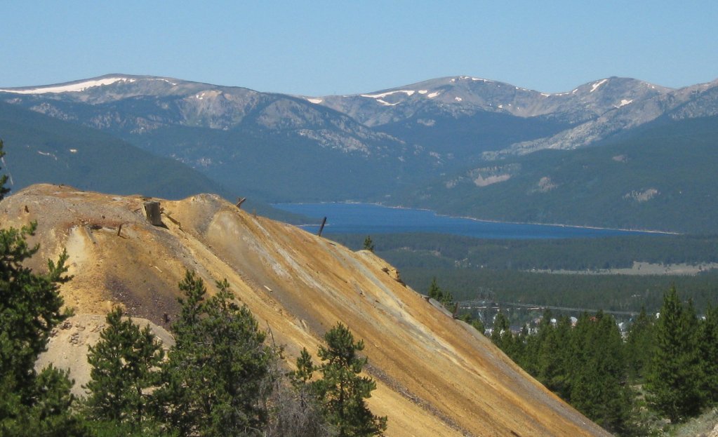
All of the digging from the boom time of Leadville has left an enduring legacy for those who live in the watershed. Much of the mining activity occurred uphill, east of the city and as a result, that area is pock marked with many large colorful tailings heaps. While the colors are interesting to ponder and sample, the ground and surface waters are greatly affected by aqueous extraction of metals from these piles.
If you stand next to one of these heaps, you can’t help but notice the smell of sulfur. The ore and tailings are enriched in sulfides and once exposed to air and water, oxidation occurs to make corrosive runoff. This is a kind of heap leaching phenomenon that will eventually exhaust itself, but only at the cost of water quality.
Boomtown Legacy (Copyright 2009 All rights reserved)
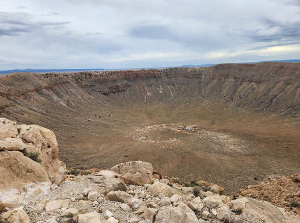
Recently we flew into Albuquerque, NM, and then took I-40 to the Barringer Meteor Crater southwest of Winslow, AZ, and 5 1/2 miles south of I-40. This was a bucket list trip for me but maybe not so much for my long-suffering spouse. I’ll spare the reader of all of the obligatory selfies.
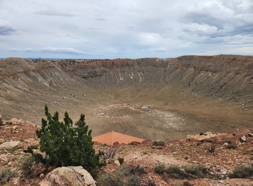
View of the Barringer Meteor Crater from the northern observation area. The brown roof in the foreground is a shelter with seating and with plaques commemorating those who own or have cared for the crater. Photo by Arnold Ziffel.
The meteor hit the AZ location 50,000 years ago and blasted a crater out of the local sandstone. The fellow who first bought the site, Barringer, believed that iron remnants of the meteor were buried within the crater, so he obtained the site by filing mining claims in 1903 that included the crater. He dug a 200 ft mineshaft into the center and drilled exploratory holes hoping to strike a rich lode of iron. Sadly for him, he found only sandstone. In fact, the fragmented remains of the meteor are scattered over the surrounding landscape. Daniel M. Barringer, a mining engineer and businessman, who bought the mining claims believed the crater was due to a meteor impact. It was many years later that professional opinions agreed that the crater was meteoric in origin. The Crater has been in in the hands of the Barringer family from the beginning.
Photo by Arnold Ziffel.
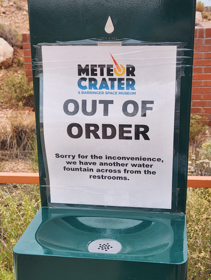
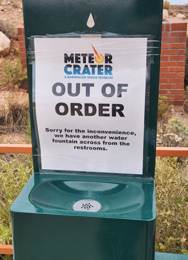
I thought this was amusing at first glance, seemingly warning that the Meteor Crater was out of order, but it was just for the water fountain. The visitor’s center has a large gift shop and an auditorium for a short video of the site and its history. The only path to the crater is through the visitor’s center. It is all private property.
The second big hole in Arizona is a whopper located north of Flagstaff. It is the Grand Canyon, of course. I had scheduled a helicopter tour of the canyon with Maverick Helicopter. at the Grand Canyon National Park Airport. They have 5 gleaming Airbus H130 helicopters that can carry 6 passengers each. Everyone gets headphones to speak in the noisy choppers.
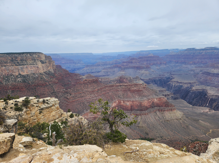
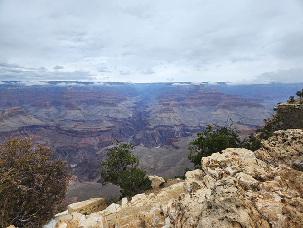
View of the Grand Canyon looking northwest from the south rim. Photo by Arnold Ziffel.
Everybody has seen countless photos with all of the breathless descriptions of the canyon, and yes, it is definitely Grand. We took a ground tour with Pink Jeep Tours in one of their custom pink Jeeps. This was in the fall shoulder season for tourism so the crowds were manageable. Gawping at it from the rim was nice but to have a real canyon experience I think you have to go into the canyon.
Note: Some of the VLA pictures are duplicated from a recent post.
Once we completed our tour of Arizona’s two gaping holes, we pointed the car east and drove to the Very Large Array (VLA) near Magdalena, NM. They put on an open house for the public on Oct. 11, so I was obligated to grab another bucket list trip. Again, the spouse unit was luke-warm but I was impressed.
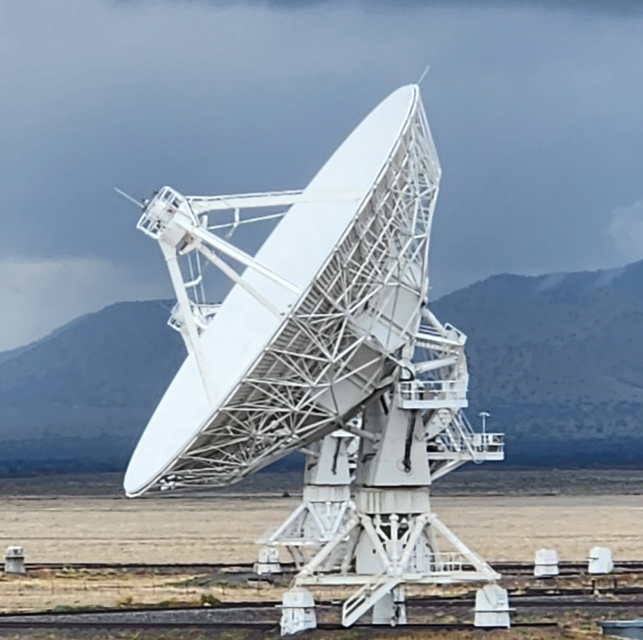
One of the 26 operating dishes at the VLA in New Mexico. Photo by Arnold Ziffel.
One of the 27 dishes is in the shop and 26 are in the field.
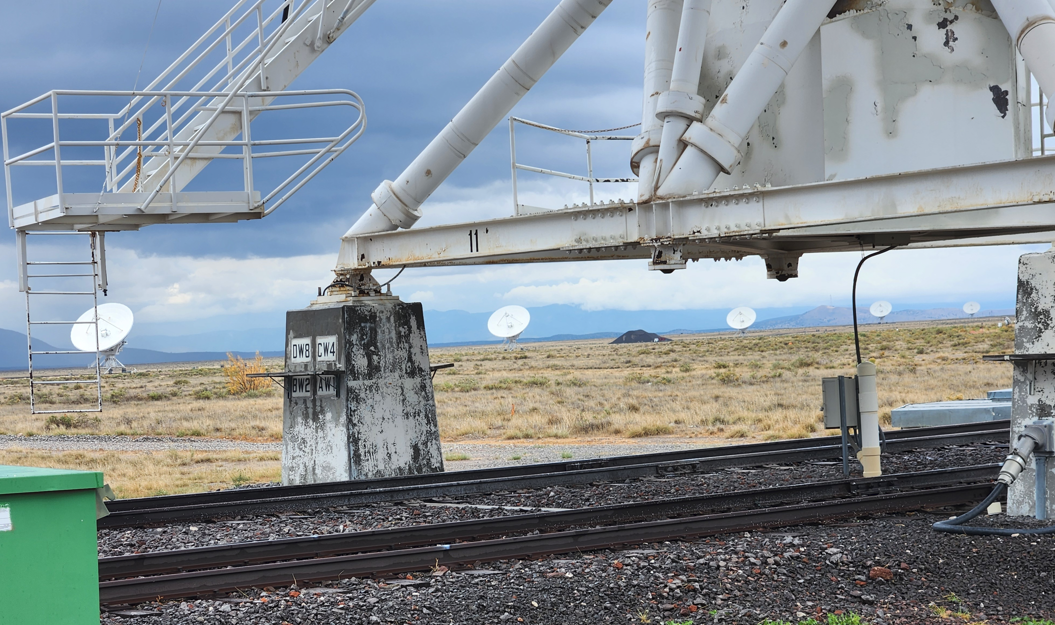
A view from under one of the dishes towards 5 more. Photo by Arnold Ziffel.
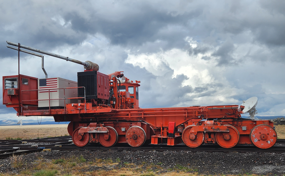
This is the machine they use at VLA to haul around the dishes when they need to be moved. When loaded it moves at 2 mph. Photo by Arnold Ziffel.
It takes the dish transport machine two weeks to reposition all 26 VLA dishes. The rails were installed to be rated for highspeed rail operations. This rating evidently ensures that dish transport is as smooth as possible.
One of the side effects of my 5 years of community theater experience on top of my beta-blocker high blood pressure meds has been that I tend not to get stage fright. I am likely to say things thar ordinarily I might not say. Beta-blockers have been successfully used to suppress the anxiety of stage fright. It works. The young radio astronomer tour guide kept referring to black holes in his spiel. Tired of this patronizing whizbang black hoIe talk, I asked him if it was possible for an astronomer to not mention black holes while speaking. He said he didn’t know. The younger VLA astronomers in the group were greatly amused by this blunt question.
When asked about the sensitivity of the VLA radio telescope system, the guide said that if you were out at the orbit of Pluto and used your cell phone, you would be the brightest radio object in the sky. Yikes.
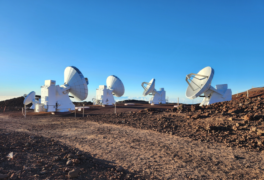
A year ago atop Mauna Kea on the Island of Hawai’i we saw these radio telescopes. The photo does not show the howling, frigid wind. It was dang cold.
Radio telescopes just below the very summit of Mauna Kea on Hawai’i Island. Photo by Ginger Rogers.
After VLA we left for Albuquerque 2 hours to the north. The next day while waiting for our flight, we visited the National Museum of Nuclear Science & History. There was a similar museum in Las Vegas, but a bit smaller. This museum was packed with artifacts from the early nuclear age.
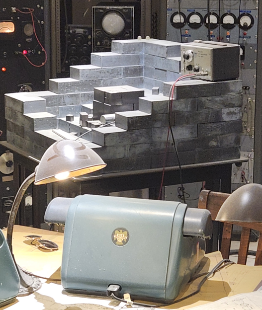
A mockup of an atomic pile used for Dragon’s Tail experiments aimed at finding the critical mass of the explosive pit. Lead bricks were piled up around a stack of what I believe are uranium cubes surrounding the fissile material. Some kind of radiation detector lies next to the pile.
At the time of the Manhattan Project, not much was known about the range of hazards of radiation exposure and dosing. And this may have been especially true for neutron exposure. Neutron activation was known, but the physiological consequences were poorly understood. Large doses of radiation correlates well with physiological effects, but in the low dose range, it begins to be sketchy. Radiation dosing tends to be stochastic in its effects.
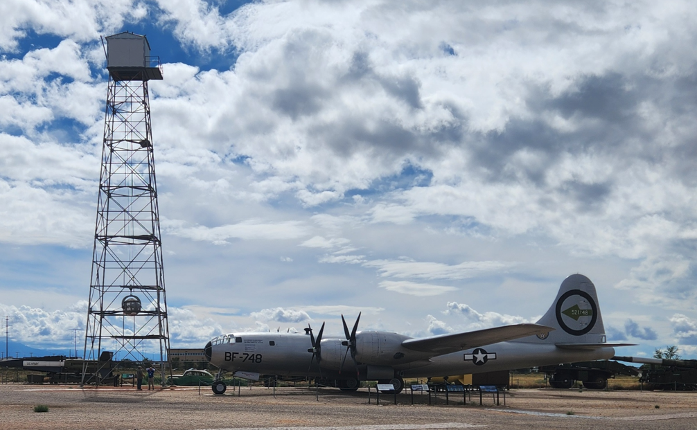
Outside of the Nuclear Museum were numerous rockets and aircraft on display. Notably a model of the tower that held the Trinity gadget. On the lower end of the tower the gadget can be seen being hoisted up into the tower.
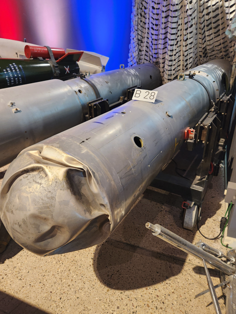
What a thermonuclear weapon looks like after it is dropped from a bomber by accident.
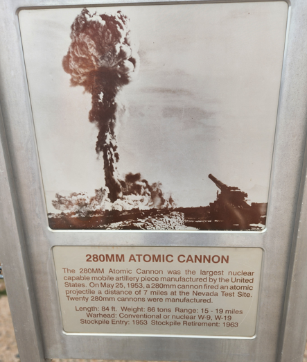
The actual cannon that fired a nuclear cannon shell and seen in film.
A photo after the nuclear cannon shell detonated.
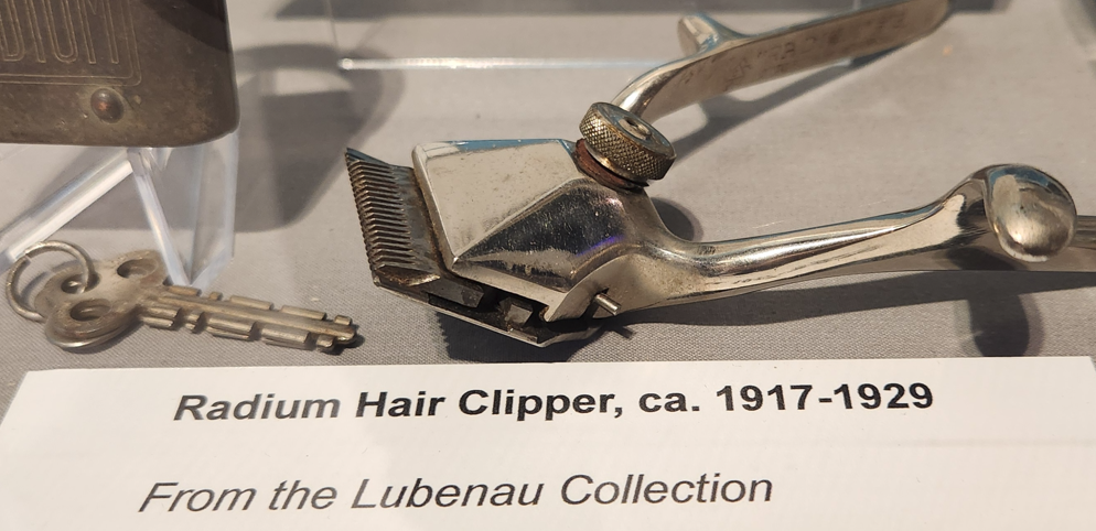
Why a radium hair clipper? Because there is a sucker born every minute.
Early atomic age children’s literature.
On my 50th birthday I actually went uranium prospecting near Idaho Springs, CO. I had a tip that pitchblende had been spotted nearby. All I managed to do was contaminate the Geiger counter with natural radioactive material that spoiled the calibration of the counter. Pisser.
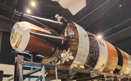
The top end of an ICBM with numerous MIRVs (the black conical objects).
A mockup of the top end of an ICBM with numerous MIRVs, Multiple Independently-targetable Reentry Vehicles.
Alert!! I spotted a Radio Shack store driving through Socorro. Driving by I could see shelves inside- it looked open for business. It was like spotting a wooly mammoth or a Dodo bird. I spent a lot of money at Radio Shack while in high school in the ’70s.
The stars lined up just right to attend an open house at the Very Large Array (VLA) near Magdalena, New Mexico, on October 11, 2025. But first, a diversion to Arizona from Albuquerque, NM. Our first stop was the Barringer Meteor Crater near Winslow, AZ. This gaping hole in the ground is maybe the best example of an impact crater anywhere. If you happen to be driving along on Interstate 40 in Arizona, is it worth the 5 1/2 mile diversion and the admission price? I’d say yes, but is it worth visiting after a long drive from Chicago for a single destination? I don’t know. Your call.
Out of order sign at the Meteor Crater. Photo by Arnold Ziffel.
At first glance the sign seems to say that the Meteor Crater is out of order.
Without a wide angle lense this is the widest shot we could get from the walkway. Photo by Arnold Ziffel.
Too small to see clearly are the remains of mining operations at the center of the crater. Mining engineer Daniel M. Barringer dug a 200 ft deep mineshaft looking for remains of the meteor believing that it should be rich in iron. Not much was found. The boiler and steam powered winch remain in place, rusting away. Barringer received a land patent for 640 acres centered on the crater. The crater remains in private hands to this day.
Gaping Hole #2.
Gaping hole #2 would be the Grand Canyon. it was my first visit. We enjoyed a helicopter tour over this famous canyon. We rode in an Airbus H130 and were treated to a smooth ride. The pilot played the song Danger Zone from the movie Top Gun as we lifted off. It was a little corny, but who cares. Helicopter rides are always spendy, but often worth it as this one was.
Is there anything new for me to say about the Grand Canyon? Ah, nope.
After the fog lifted out of the canyon, this appeared. Photo by Arnold Ziffel.
The stratigraphy of the canyon is fascinating. The Grand Canyon has been eroded out of the Colorado Plateau by the Colorado River over geological time. As the plateau lifted upwards, the river cut downwards. The many buttes and ridges in the canyon remain to show the fickle nature of erosion. Meteoric water and gravity cut through the canyon walls from the rim all the way down to the present course of the river- a mile deep in some places. The basement rock of granite is even exposed in some locations. It is striking how the many layers of sedimentary rock have stacked from such great depths. Deep geological time is impossible to comprehend. Each layer was put in place in a way that driven by the climate and location of surface of the earth at a particular time. Many variations of sandstone, limestone and dolomite are found resulting from the unique sedimentation processes of the time.
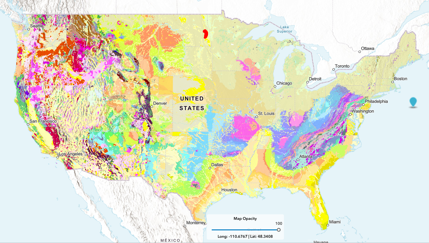
The United States Geological Survey, USGS, has released an interactive geological map that includes 4 layers of stratigraphy- Surface, Quaternary, Pre-Quaternary and Precambrian layers with color coded rock units displayed. A click of the cursor on the map reveals the type of rock unit chosen. The website is called The Cooperative National Geologic Map.
The state of Nevada is quickly becoming the leading source of lithium in the USA and beyond. In the state there will soon be three major types of lithium ore beneficiation- Brine evaporation, hard rock extraction and lithium clay extraction. Nevada already has in excess of 180,000 active mining claims amounting to 49 % of the total BLM national inventory. In addition to this, Nevada has “198 authorized mining plans of operations, and 282 active exploration notices.” Nevada has a long history of fruitful gold and silver mining.
Nevada had earlier won the gold deposit lottery with the Carlin Trend occupying much of the northwestern section of the state. The Carlin Trend has become an archetype in gold mining. These deposits are often described as Carlin-type “invisible gold” ore deposits. Such a deposit is characterized as sediment hosted and disseminated [Editor: disseminated seems like a bummer]. Gold in such deposits are typically invisible and often only detected by lab analysis. According to Wikipedia, most of the gold mines in the Great Basin of the western US are of the Carlin-type.
But, enough about gold and on to lithium
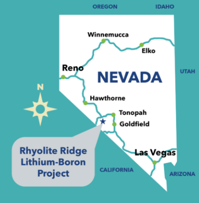
After 6 years of regulatory scrutiny, a new lithium-boron open-pit mining operation in Nevada operated by Australian mining company ioneer has just been approved by the Bureau of Land Management, BLM, for Rhyolite Ridge. The mine is located in the Basin and Range Province near the southwest border of Nevada and California.
The old joke used to be that a mine is a hole in the ground with a liar standing at the top. With the independent economic evaluations available today as part of the disclosure to investors, the likelihood of being duped by fake or salted deposits has dropped considerably. However, the market value of the ore in the future is still subject rapid and unpredictable change.
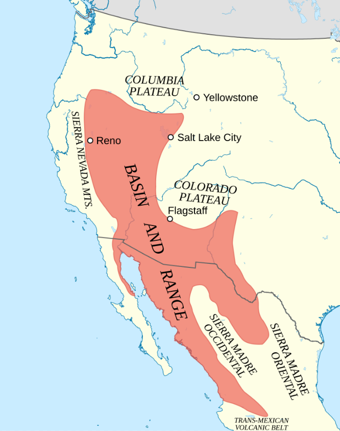
If you find yourself flying over Nevada on a clear day, you can easily see the basin and range features of the terrain. Nevada occupies only a small part of the total area. The basin and range province extends north to the Columbia Plateau and south into the Central Mexican Plateau.
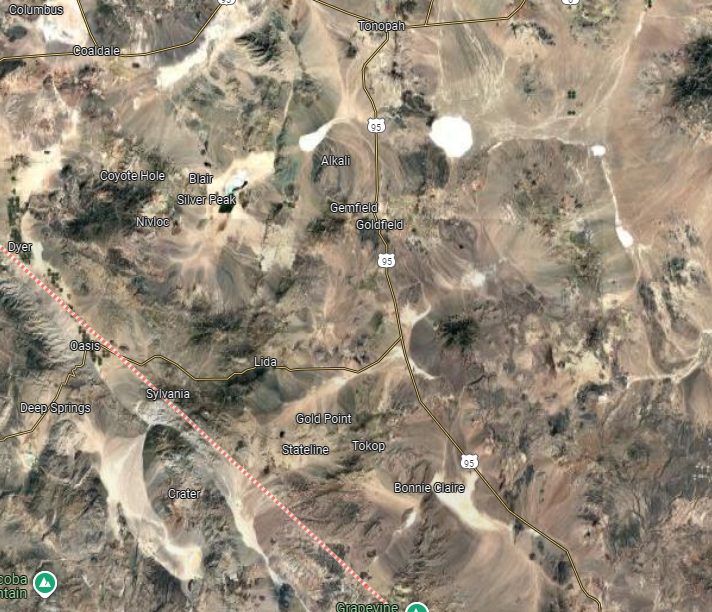
A very small part of Nevada’s basin and range landscape as viewed from above the Rhyolite Ridge area in Nevada. Image from Google Maps.
The Basin and Range Province of North America. Image from Wikipedia.
Rhyolite Ridge Lithium-Boron Project
The BLM approval opened up $1.19 billion of potential funding of which $700 million is from a US government loan. According to Mining.com, Rhyolite Ridge is the first new lithium mine in 60 years and the first new boron mine in the last century in the US. [Note: I have to assume “new” means new hard rock mineas opposed to brines or evaporites] While the approval by BLM has opened some doors to funds, not everyone is convinced of the major investor’s liquidity.
So, what is rhyolite?
I can’t improve on the definition found in Wikipedia, so I’ll just quote it with the links intact-
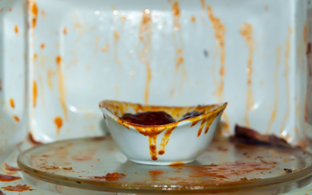
If you have ever seen molten glass and noticed its high viscosity, this gives an idea of what high silica content does to lava. The higher viscosity provided by the silica component suppresses the release of gases until nearer the surface where they are released as bubbles with vigor. It is very much like a comparison between boiling pasta water and boiling marinara sauce. The marinara sauce spatters badly due to its viscosity but the pasta water just does a rolling boil.
Source: Mashed.com. Spattering is a universal behavior of hot, gassy fluids. In this case the gas is steam. Magma also contains steam.
The Rhyolite Ridge lithium-boron (LiB) deposit is said by some to be the only known LiB deposit in the US and only one of two known in the world.
“The Rhyolite Ridge mine will run for 22 years. It will produce 22,000 tonnes of lithium carbonate a year. That’s enough to power 370,000 electric vehicles. It will also produce 170,000 tonnes of boric acid, according to the company. The boron contributes 30% to 40% of the mine’s revenue, providing a buffer against lithium market volatility.” –Mining.com
Around the world new economic lithium deposits are being discovered now and then, and a few are being readied for mining. It was announced recently that BLM has approved operations at the Rhyolite Ridge Lithium-Boron Project in southwestern Nevada.
What is interesting about this Rhyolite Ridge project is that it aims to produce both lithium and boron. I’m not an engineer so maybe I’m overly impressed, but the processing plant they propose seems very clever. They will produce their own sulfuric acid from sulfur and extract waste heat for use in generating steam for evaporation of the extracts and electricity. They are completely off the energy grid.
The extracted ore, now called ROM or run-of-mine, is transported to the plant straight from the mine and sized by crushing to 20 mm pieces. The crushed ROM is then taken to a series of sulfuric acid extraction vats and leached for ~ 7 days. The pregnant leach solution containing the lithium, boron and soluble impurities is then taken to evaporators with repeated crystallizations and, using differential solubility, separates the lithium component from the boric acid. In the end they produce lithium carbonate. The video does show a soda ash (sodium carbonate), Na2CO3, silo so I assume that is where the carbonate comes from to produce lithium carbonate, Li2CO3 and to neutralize residual sulfuric acid.
Silver Peak Lithium Brine
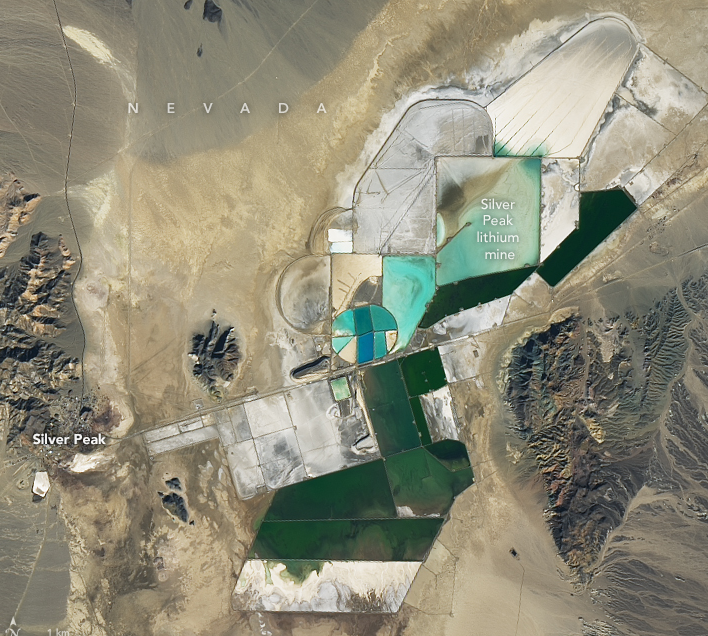
Of interest is the nearby Silver Peak lithium brine operation operated by Albemarle just a few miles to the north of Rhyolite Ridge. The Google Maps image below shows the evaporation ponds at the Silver Peak lithium operation. Silver Peak produces both technical grade lithium carbonate and lithium hydroxide.
Image from the Operational Land Imager-2 (OLI-2) on NASAs Landsat 9. A view from space of the Silver Peak lithium brine evaporation ponds in SW Nevada.
McDermitt Caldera: Thacker pass
Another large lithium deposit was discovered in the McDermitt Caldera along the Nevada-Oregon border. Within the caldera is the Thacker Pass Lithium Mine. This lithium deposit was approved for open-pit mining by BLM on January 15, 2021, though it has been plagued by protests and an injunction. As with the rest of the McDermitt Caldera lithium, the Thacker Pass lithium is described as a lithium rich clay deposit. This is unique for lithium mines since brine extraction and hard rock mining of spodumene have been the norm. Thacker Pass’ lithium deposit is the largest known volcano sedimentary deposit in the US at an average grade of 0.22 %.
In 2023 GM invested $650 million in the Canadian Lithium Americas Corp. The Thacker pass operation is through its wholly owned subsidiary Nevada Lithium, LLC, which is responsible for production. Car giant GM’s investment gives them exclusive access through the first phase of production. Lithium Americans has received a conditional approval for a $2.2 billion loan from the US Department of Energy.
The Thacker Pass measured and indicated lithium resources are 13.7 million tons of lithium carbonate equivalent. Lithium Americas calculates that the recoverable lithium is worth $3.9 billion.
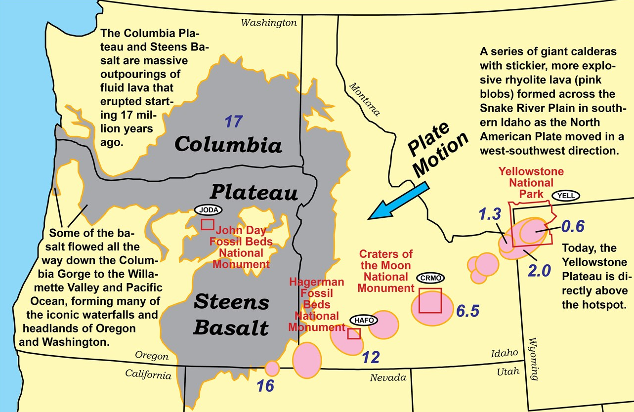
Interestingly, the McDermitt Caldera is possibly the oldest of a sequence of calderas produced by the Yellowstone Hotspot. The McDermitt Caldera amounts to a lava dome that collapsed ~16.4 million years ago forming a large caldera within which several smaller calderas have formed and in which later filled with water forming a lake over the tuffaceous ash. Over time the lake produced sediments that were deposited on the floor of the lake. The source rock is rhyolite which is usually the case in the state.
The Yellowstone hotspot stays relatively constant while the crust moves over it, leaving a trail of calderas and a record of volcanic activity on the surface behind. The McDermitt caldera is labeled ’16’. Source: National Park Service.
Briefly, the lithium clay is excavated, gravel and rocks are removed, and the clay is suspended in water to form a slurry. The slurry is leached by adding sulfuric acid that is produced on-site and the lithium in the ore is extracted into the acidic liquor. Finally, the dissolved lithium is recovered as lithium carbonate and lithium hydroxide. Gangue material is deposited back into the excavated sections of the mine.
The McDermitt caldera contains many breccia and fracture zones and associated with these are deposits of other metal ores. Specifically, mercury from cinnabar ore bodies and uranium from autunite (uranyl, U6+) (Ca(UO2)2(PO4)2·10–12H2O) and pitchblende (uranate, UO2, U4+) ore bodies. Mercury reserves in the caldera, according to USGS, are estimated to be 400,000 flasks.
A Mercurial Rambling
Mercury has been packaged (and still is) at 76 pounds to the flask. This measure got its name from the mining and smelting of cinnabar in the mountains of Peru. One site was particularly rich- Huancavelica, Peru. The Spaniards had known prior to their arrival to the New World that liquid mercury could dissolve gold from ore to produce what we now know as a mercury amalgam. With very strong heating the mercury could be driven off as vapor to recover the precious metal.
Spain had its own cinnabar mine in what is now Almadén, Spain, which produced over 250,000 tonnes of mercury. The Spaniards had considerable experience with mining, refining and using mercury prior to discovery of it in the new world. Mercury was quite valuable to the Spaniards but they were faced with transporting it from, say, Huancavelica, Peru, to the Carribean coast where their ships could load the mercury and distribute elsewhere. Anecdotally, it has been estimated that for every ounce of gold produced in the new world, ten ounces of mercury were consumed.
Luckily for the 49er gold rush miners, cinnabar had previously been discovered in California. You can actually visit the old New Almaden mine museum south of the Bay Area. It is worth a trip if you are in the area.
The Spaniards figured that a man could carry what turned out to be as much as 76 lbs of mercury through difficult terrain to the Caribbean coast. Even better for the Spaniards, they knew how much gold could be extracted per pound (or whatever unit) of the mercury they dispensed. This gave them an idea of how much gold to expect and closer control of the mines. By controlling mercury, they controlled who could use it for mining and how much gold they could recover.
Back to lithium
As of this writing, Albemarle is the largest producer of lithium in the US. But the largest known deposit in the US is at Thacker Pass. The Albemarle Silver Peak lithium brine operation is legally defined as placer mining whereas the Thacker Pass operation is lode mining. The word ‘legally’ is used because any claims filed are restricted to placer or lode mining- one does not transfer to the other.
A Word or Two About Rhyolite
Rhyolite is a type of volcanic rock characterized as a ‘fine-grained extrusive igneous rock‘. Its color can vary from pale light grey to pinkish when composed of mainly quartz and feldspar or dark when of a mafic, low silicate composition was present. A quiet eruption of lava gives a solid, denser rhyolite whereas in an explosive eruption can produce the vesicular pumice. The lower density of pumice allows it to float on water. Erupting volcanic islands can produce floating rafts of pumice in the nearby waters. As magma rises in the throat of a volcano, the pressure drops and dissolved gases can form bubbles which, if they fail to disengage from the magma completely, can be ejected into the cooler air and freeze into ‘foamy’ structure. [Note: the word ‘foamy’ is my own and earth science people cannot be blamedfor this.]
A Bit More About McDermitt Caldera
The United States Geological Survey (USGS) published open-file report 76-535 in 1976 titled Geology and Ore Deposits of the McDermitt Caldera, Nevada-Oregon. A 1978 USGS open-file report by Newmont Exploration, Ltd., 78-926, James J. Rytuba and Richard K. Glanzman, Relation of Mercury, Uranium and Lithium Deposits to the McDermitt Caldera Complex, Nevada-Oregon, goes into greater detail on the three minerals.